A Friends' of Scott Creek Conservation Park Project
http://www.friendsofscottcreek.org
To restore threatened wetlands at Scott Creek Conservation Park by rehabilitating degraded upland swamps, bogs, spring-fed gullies and seasonal creek lines.
PROJECT SUMMARY :
Our project will restore native habitat along 8 headwater creeks of the Scott Creek sub-catchment and reduce threats to 4 EPBC listed species and 26 AMLR threatened species. We will strategically remove large infestations of serious environmental weeds such as Blackberry, Tree heath, (Erica spp), and Willow to facilitate natural regeneration. We will undertake targeted tube-stock revegetation to improve and expand native habitat in the regionally important reserve, Scott Creek Conservation Park in the Mount Lofty Ranges, a national biodiversity 'hot-spot'. We will track the effectiveness of implemented project actions with appropriate monitoring techniques, adapt management to observed ecosystem responses, and engage the local community, landholders, and schools in the project.
INTRODUCTION :
NATIONAL PERSPECTIVE:
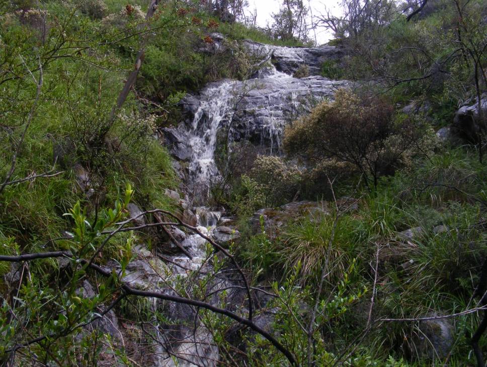
Riparian habitats are where land and water ecosystems meet. They are vital places supporting high levels of biodiversity and being critical in controlling flows of energy and nutrients between the land and the water (Naiman & Decamps, 1997). This is true even on creeks and gullies that only occasionally carry flowing water.
Human settlement has always been focused on water and is often a main determinant of riparian structure and function (e.g. Dynesius & Nilsson, 1994)
One of the biggest impacts on riparian areas has been the introduction of domestic stock, with grazing being the major land use over 60% of Australia’s land surface (Wilson, 1990).
Stock concentrate around water sources, which means riparian and wetland habitats suffer greater impacts from domestic and feral grazing than dryland areas (Robertson, 1997; James et al. 1999).
Early settlers farmed riparian areas prior to using other water sources such as dams and bores. These impacts have led to extensive loss of ecological condition in riparian areas of Australia.
REGIONAL PERSPECTIVE:
When Adelaide was first settled by Europeans there was a shortage of water for farm production. This led to the riparian regions of the Mount Lofty Ranges being cleared and drained for farming. However, when it was discovered that water could be found in areas more suitable for farming by developing bores and dams, the riparian areas were abandoned. These areas were then colonised by introduced plants such as blackberry, tree heath and broom.
There are few surviving examples of these wetlands remaining in the region and most of those that remain are rapidly degrading through livestock grazing, chronic weed invasion, active erosion, and altered water regimes.
The result of this can be seen by considering the list of threatened plants of the Mount Lofty Region. While less than 20% of all plant species of the Mount Lofty Region are riparian species over 60% of the rare and endangered plants of the region are riparian.
As the conservation values of Scott Creek Conservation Park are very high and there has been considerable success removing introduced weeds and establishing stable native vegetation in a number of riparian zones already, it makes sense to continue and accelerate this work.
With government funding for supporting biodiversity virtually disappearing, it is imperative that new systems be developed for the community to take over these responsibilities.
One of the main aims of this project is to take the problem of biodiversity loss to the community. This project will be totally planned, funded and carries out by the community. It will be a demonstration of a new way of meeting the challenges we face.
The project will be owned by the community. Local schools (Mylor, Heathfield, Scott Creek and others) will be invited and encouraged to participate.
We will offer on the ground training to those who wish to follow a career in conservation. It is vitally important that we use this opportunity to not only restore the riparian habitats of Scott Creek Conservation Park, but to show how so that others can replicate the project elsewhere.
The project will be continually monitored, evaluated and recorded so that it is clearly shown what results were achieved and how they were achieved. It will be a blueprint of a new way of caring for our biodiversity.
An additional threat facing our plants is climate change. With the gradual drying out of our riparian habitats, through water table lowering by bores and rainfall changes, means that riparian plants need to move downstream to damper areas. This is not possible if the creek is blocked by sections of weeds such as blackberries.
It will also be necessary for us to assist this process by growing tube stock from selected species and planting them in suitable areas which have been cleared of weeds. A good example of this can be seen at Almanda Creek.
OBJECTIVES :
To regenerate threatened native wetland vegetation by reducing competitive displacement by serious environmental weeds of national significance (Sallow willow, Blackberry & Boneseed), supplement resulting natural regeneration through locally provenant tube-stock plantings, and slow surface flows by re-snagging eroding stream channels and through regenerating native groundcover.
The project will also restore and increase the extent and quality of habitat for 26 state threatened plant species and 2 state threatened ecosystems, namely:
- Annual fern- (Anogramma leptophylla) - RARE
- Coral fern (Gleichenia microphylla) – RARE
- Creeping raspwort (Gonocarpus micranthus) - RARE
- Fishbone water fern (Blechnum nudum) – RARE
- Hard water-fern (Blechnum wattsii) – RARE
- King fern (Todea Barbara) –ENDANGERED -Historically in Park and is on nearby property-will be re-introduced
- Knobby Juncus (Juncus amabilis)-VULNERABLE
- Lagoon grounsel – (Senecio runcinifolius)-RARE
- Lax twig-rush (Baumea laxa) – RARE
- Leafy twig-rush (Cladium procerum) – RARE
- Little Xanthosia (Xanthosia tasmanica) - RARE
- Long-leaf creeping Poa (Poa umbricola) – RARE
- Matted Pratia (Pratia pedunculata) - UNDESCRIBED
- Matted St Johns wort - (Hypericum japonicum) – RARE
- Mount Lofty Ranges speedwell (Veronica derwentiana ssp homalodonta) – CRITICALLY ENDANGERED NATIONALLY
- Native mint (Mentha diemenica) – RARE
- Pale twig-rush – (Baumea acuta) - RARE
- Pale wood-rush – (Luzula flaccida) - VULNERABLE
- Ruddy ground fern (Hypolepis rugulosa) - RARE
- Slender bottle-daisy –(Lagenophora gracilis) - VULNERABLE
- Soft grass sedge (Carex gunniana) – RARE
- Swamp Mazus (Mazus pumilo) – VULNERABLE
- Swamp Pratia (Pratia puberula) - VULNERABLE
- Swamp raspwort (Haloragis brownii) – RARE
- Swamp wallaby grass (Amphibromus archeri) - RARE
- Waterblinks - (Montia fontana ssp chondrosperma) - VULNERABLE
and
- Manna gum Woodlands - VULNERABLE
- Silky tea-tree Shrublands – ENDANGERED
This project is integrated with regional programs aimed at protecting biodiversity and recovering threatened species and ecosystems. The project will also contribute to improving catchment riparian zones, mitigate erosion and reduce environmental weed invasion. Abating the impact of key threats will reduce the risk of local extinctions for threatened wetland plants and help ensure long- term species survival.. It is anticipated the project will have numerous positive effects on surrounding areas by:
- increasing the area of threatened wetland ecosystems being actively managed;
- improving viability of threatened wetland plant populations;
- reducing key threats to surviving wetlands and improve their integrity & viability;
- reversing the decline in quality of native vegetation in a highly cleared region;
- fostering and maintaining working partnerships with adjoining landholders; &
- supporting & focussing community involvement in wetland protection.
- Support the 24 years and remarkable results already achieved by a small, but extremely dedicated band of volunteers.
PROJECT DELIVERABLES:
Hectares to be managed:
A total number of 93 hectares will be managed including 20 hectares of wetlands and 60 hectares of adjoining weed infested land. Weeds to be managed are:
Bitou Bush/Boneseed-Declared
Blackberry-Declared
Brooms-Spanish Broom- Declared
Gorse-Declared
Willows-Declared
Tree heath
Hawthorn
Watsonia-Declared
European Olive-Declared
Radiata Pine
Golden bamboo
Sweet Briar-Declared
Sweet Pittosporum
Bluebell Creeper
Sallow wattle
People Involved:
The Friends of Scott Creek has 40 core members and a larger number of affiliated supporter groups and individuals. Two members have won Volunteer of the Year Awards and two, the Centenary Medal for Services to the Environment. The Group has also won awards in recognition of their work in the long term habitat restoration of Scott Creek CP. Many of the members have long-term experience with over 24 years implementing similar work and there is ample skill and capacity for the organisation to draw upon in delivering the project. Several members are excellent field botanists who also have a long term interest in birds and natural history in general.
Park Rangers from the Department of Environment, Water and Natural Resources and members of the Threatened Plant Action Group will also provide collaborative support and relevant technical advice as required for successful completion within the outlined budget and timeline of the project.
Contractors:
Although there are a number of people who are happy to be involved it will be necessary, and in fact pivotal to the success of the project, to have the “heavy lifting” carried out by contractors using selective herbicides. These contractors will be skilled in administering selective herbicides properly and competently with a minimum of collateral damage. The Group only use one contractor for work requiring good plant ID skills and have every confidence in their ability to minimise “off target” damage.
Monitoring:
We will monitor and evaluate the outcomes of the project by developing a Monitoring, Evaluation, Reporting and Improvement (MERI) Plan to help us manage, track and report progress towards achieving the project objectives. Outcomes will be evaluated by establishing appropriate monitoring and information systems that track responses of managed sites and assess the effectiveness of implemented on-ground actions. Representative monitoring sites will be established along targeted sections of waterways and adjoining areas. We will establish photo-points in strategic locations to observe changes in vegetation and habitat structure. Permanent monitoring quadrats will be set up in priority sites and appropriate ecological metrics will be utilised to track changes in ecosystem composition, diversity and other condition attributes. Monitoring of threatened bird and plant populations will be undertaken using methods tailored to species life-form and spatial distributions. Detailed ecosystem maps will be made for the project area indicating ecological community types, threatened species populations, threat foci such as weed infestations, and other attributes of importance in the project area.
Conservation measures taken:
The creek line and bog areas of Scott Creek have received funding through the NHT and SADEH for on-ground works. This has involved a partnership between the Friends of Scott Creek Conservation Park, Threatened Plant Action Group, SA Department for Environment and Heritage, SA Water and Catchment Boards, State government programs (SA Urban Forest Program) and National Park Staff and Friends Group. Action plans are being prepared for the management of the bog areas. Scott Creek swamps have been identified as important wetland sites by the Friends of Scott Creek and the Threatened Plant Action Group. Current scientific research: Ongoing botanical monitoring. Some past studies on Southern Brown Bandicoot and a current bird banding program by the FOSCCP.
Current conservation education: Some interpretive signage is provided on walking tracks near to swamps. The FOSCCP continue to conduct swamp and creekline tours in the park for interested groups and individuals.
A comprehensive Bird Brochure has been produced by FOSCCP. A powerpoint presentation covering creek line restoration methods used by the Group was been made to the Weed Management Society Forum in 2012 and the same presentation has been made to several other Friends Groups since.
METHODS:
WEED MANAGEMENT:
Year 1:
Choose one of the creek systems. Completely and carefully map it showing the weed infestations, the threatened plants by species, the areas that need to be sprayed by contractors and the areas that can be completely managed by volunteers. A timetable will be drawn up for the areas that can be managed by volunteers. A contractor will be chosen to deal with the areas that need spraying and they will be sprayed.
Year 2:
The system will be again mapped and treated as before. This will be continued year after year needing less spraying each year until it can be completely managed by volunteers.
When confident that resources are available the next creek system will be added and treated as the first and so on. The rate of progress will depend very heavily on the results obtained. Past experience makes the ten year timetable seem achievable. However follow up is forever although it is hoped that spraying will not be needed again.
REGENERATION MANAGEMENT:
As the weeds are removed it is important that they be replaced with suitable local provenant species. This will need to be integrated into the spraying/weeding program as timely planting can reduce the need for other resources. The resources exist within the volunteer group to do this work.
FUNDING MANAGEMENT:
The two ingredients needed to successfully carry out this project are the funds to pay contractors to do the “heavy lifting” and the workforce to manage the “follow up” work. These two ingredients are really the same. An interest must be created to encourage people to help. Some will choose to give labour, others will choose to give financial support.
However those who choose to assist with this project rightfully expect a reward. This expectation will be satisfied in a variety of ways.
Those who assist with funding need to see that their funds are actually achieving results. It is proposed to publish an annual report setting out exactly what has been achieved over the previous year. This report will be audited by a competent botanist. As well as demonstrating to our supporters that we have spent their money wisely these annual reports will also be the basis of a book called something like “How important riparian habitat can be restored to working systems and be given a sustainable future with the support of the community”. This annual report could be distributed amongst like minded individuals such as walking groups, friends of parks groups, etc. each year requesting help. Each time a discovery is made at the Park, such as one of the undescribed species being described, a new species found or a successful regeneration programme completed, the media would be interested. Our local paper, the Mount Barker Courier, is always asking if there are stories for them. We could easily get a monthly spot in the Mount Barker Courier on our latest news. We have reason to be confident that we can raise half the necessary funds.
VOLUNTEER MANAGEMENT:
Those who assist with labour will have the added reward of “education”. Probably the most rewarding experience is actually learning. Learning about our bush. Learning what plant is what. Learning about the interactions in the web of life. Etc.
Those who give us half a day of their labour will be offered one hour of education.
MEDIA MANAGEMENT:
Probably the most important part of making this project work is media management. In today’s world it can be difficult to get anyone’s attention. People are only interested in something if everyone else is too. The day of individuality is probably over. However! We are fortunate in having members within our group who can do this.
For example, Ian Henchke on Morning 891 not long ago, was talking about how it was time to find a new way of funding natural environment management. Presenting this project on such a radio show would do very well to keep such a conversation going.
BUDGET:
It is envisaged that a total of approximately $650,000 will be required over ten years to complete the program after which volunteers should be able to carry on. Of the $650,000 the volunteer group will input $450,000 (in kind) and we need to raise the other $200,000 over ten years. We are confident that we will be able to raise these funds.
AREA DESCRIPTION:
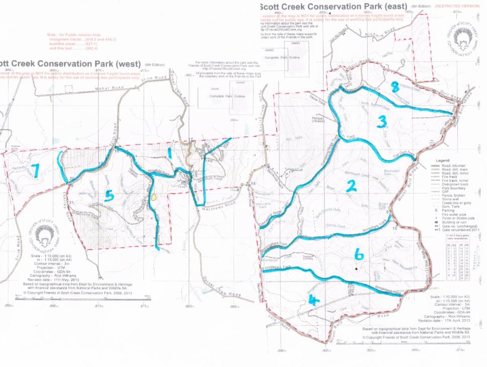
1. Almanda Swamp and Creek System:
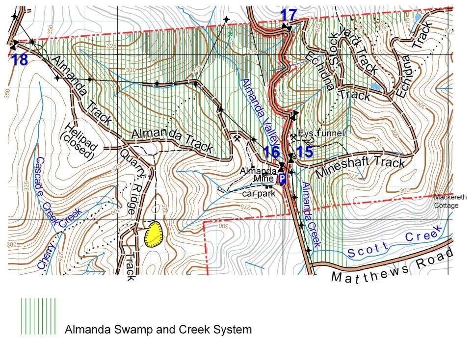
Dominant riparian vegetation includes Leptospermum lanigerum, Acacia retinoides, Blechnum minus, Gahnia sieberiana, Carex appressa and Baumea tetragona Lycopus australis. Dominant buffer vegetation includes Eucalyptus leucoxylon, Eucalyptus viminalis,Acacia pycnantha, and
Aquatic vegetation class: Rooted vascular.
2. Blackwater and Fern Gully System:

Dominant riparian vegetation includes: Rubus spp, Gahnia sieberiana, Carex apressa, Senecio hypoleucus, and Goodenia ovata, Dominant buffer vegetation includes Eucalyptus obliqua, E. cosmophylla, E. fasciculosa, Pultenaea daphnoides, Bursaria spinosa, Lepidosperma semiteres, Hakea carinata, Acrotriche fasciculiflora, Aquatic vegetation class: Rooted vascular.
3. Bushrat Creek swamps
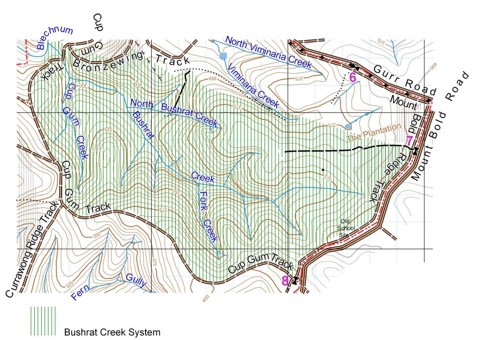
Dominant riparian vegetation includes: Leptospermum lanigerum, Acacia retinoides, Gahnia sieberiana, Blechnum minus, Carex apressa, Baumea tetragona and Goodenia ovata. Dominant buffer vegetation includes Eucalyptus obliqua, Pultenaea daphnoides, Lepidosperma semiteres, Hakea carinata, Acrotriche fasciculiflora, Pteridium esculentum and Lepidosperma semiteres. Aquatic vegetation class: Rooted vascular, Algae.
4. Cave Creek System:
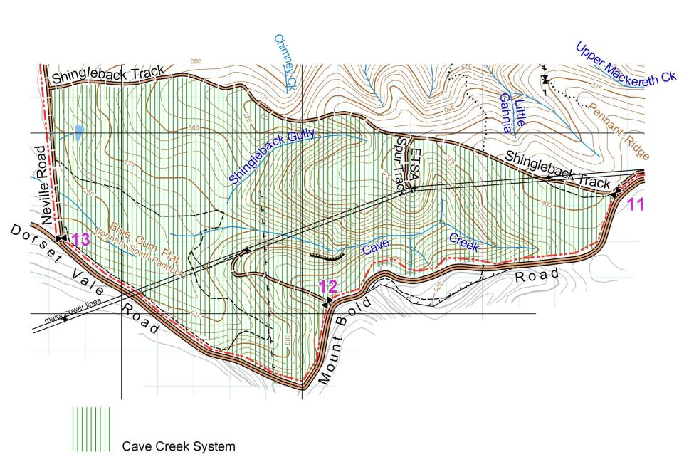
Dominant riparian vegetation includes: Gahnia sieberiana, Carex apressa, Baumea tetragona and Goodenia ovata. Dominant buffer vegetation includes Eucalyptus obliqua, Banksia marginata, Pultenaea daphnoides, Bursaria spinosa, Lepidosperma semiteres, Hakea carinata, Acrotriche fasciculiflora, Pteridium esculentum and Lepidosperma semiteres. Aquatic vegetation class: Rooted vascular.
5. Derwentia Creek System:
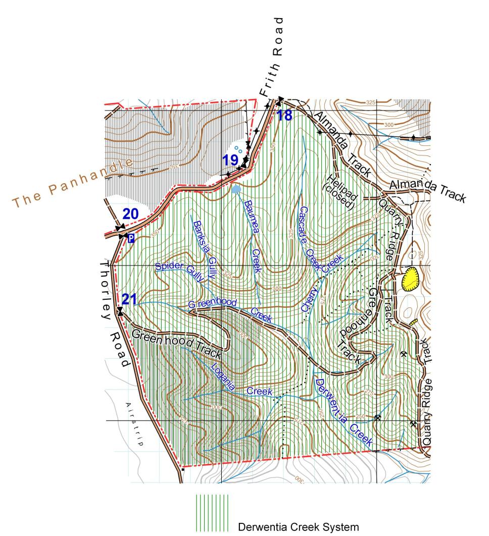
Dominant riparian vegetation includes: Leptospermum lanigerum, Acacia retinoides, Gahnia sieberiana, Blechnum minus, Carex apressa, Baumea tetragona and Goodenia ovata. Dominant buffer vegetation includes Eucalyptus obliqua, E. viminalis, E. leucoxylon, Pultenaea daphnoides, Lepidosperma semiteres, Hakea carinata, Acrotriche fasciculiflora, Pteridium esculentum and Lepidosperma semiteres. Aquatic vegetation class: Rooted vascular, Algae.
6. Fox Bog/Mackereth Creek:
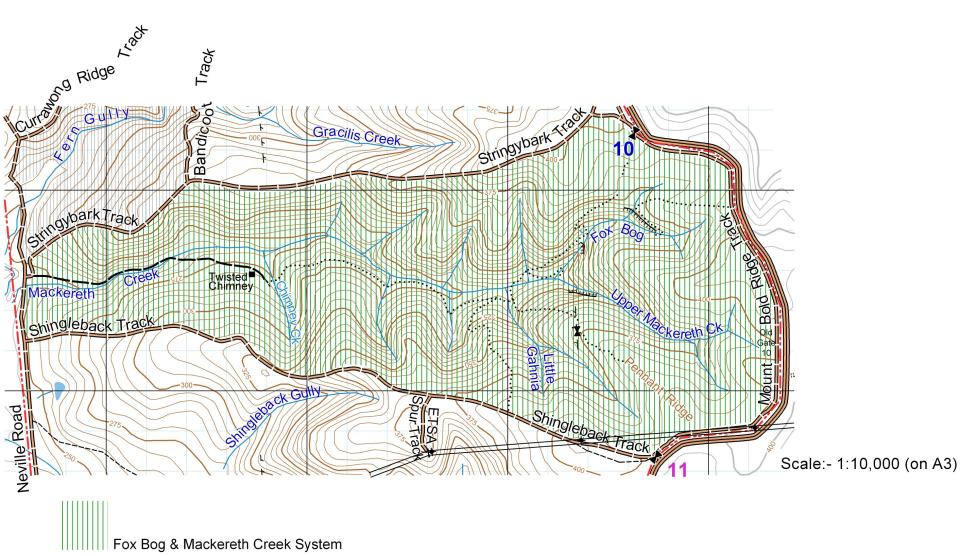
Dominant riparian vegetation includes Leptospermum lanigerum, Acacia retinoides, Acacia melanoxylon, Gahnia sieberiana and Blechnum minus. Dominant buffer vegetation includes Eucalyptus obliqua, and Acrotriche fasciculiflora. Aquatic vegetation classes: Rooted vascular, Floating vascular- Azolla pinnata, Spirodela punctata?
7. Panhandle Creek System:
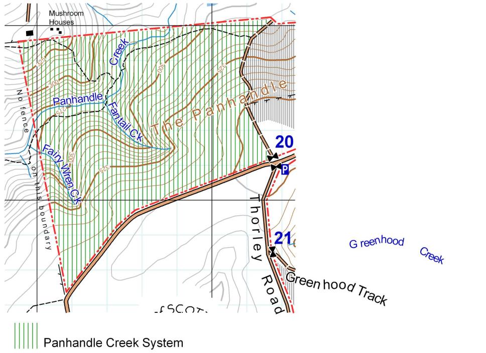
Dominant riparian vegetation includes: Rubus spp, Gahnia sieberiana, Carex apressa, Baumea tetragona and Goodenia ovata, Leptospermum lanigerum. Dominant buffer vegetation includes Eucalyptus obliqua, E. viminalis, E. leucoxylon, Banksia marginata, Pultenaea daphnoides, Bursaria spinosa, Lepidosperma semiteres, Hakea carinata, Acrotriche fasciculiflora, Pteridium esculentum and Lepidosperma semiteres. Aquatic vegetation class: Rooted vascular.
8. Viminaria Creek:
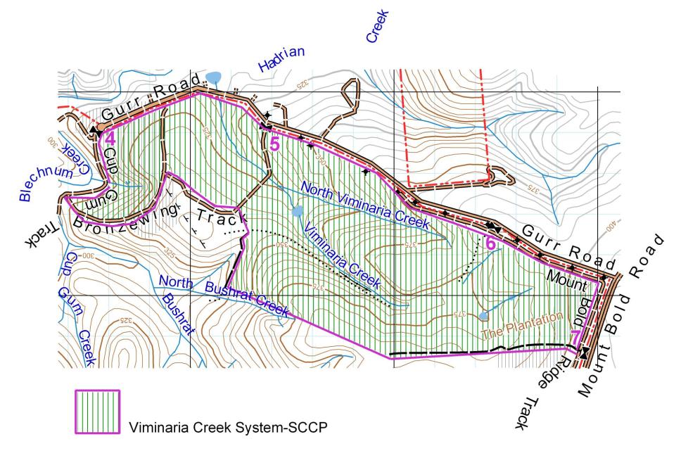
Dominant riparian vegetation includes Acacia retinoides, Leptospermum lanigerum, Viminaria juncea, Gahnia sieberiana, Blechnum minus, Carex appressa and Baumea tetragona. Dominant buffer vegetation includes Eucalyptus obliqua, Pultenaea daphnoides, Austrostipa muelleri (Not too close)and Aquatic vegetation class: Rooted vascular.
Biographic region:
Lofty Block.
Council:
Adelaide Hills and Onkaparinga.
Other listed wetlands in same aggregation:
Closest listed wetlands are at Englebrook 10 km north east and Cleland 12 km north.
Wetland type:
B15, B13, B9
Criteria for inclusion:
1,2,3,5,6
Site description:
The eight perched swamps occur within Scott Creek Conservation Park. All swamps are examples of rare and threatened upland swamps in the southern Lofty Block. They contain habitat for the nationally endangered Southern Brown Bandicoot (Isoodon obesulus obesulus), threatened wetland plant species and a state endangered ecosystem for South Australia.
Physical features:
The eight wetlands include perched swamps around gully headwaters of permanent first order streams, swamps within drainage depressions, and hillside bogs on sandstone and quartzites of the Warrina supergroup and Burra group. Soil types: Silty, clay loams with high organic matter. Rainfall: 880-1000 mm.
Hydrological features:
Permanent palustrine and rheotrophic spring and stream fed perched swamps in a major tributary (Scott Creek) of the upper Onkaparinga River catchment.
Significance:
The Scott Creek swamps contain unique wetland vegetation in South Australia including 120 indigenous plants species. Twenty Six plant species are threatened at a State level (National Parks and Wildlife Act 1972). Sixty two are threatened within the Southern Lofty Region and a number of species are undescribed.
The swamps also provide habitat for the Nationally Endangered Southern Brown Bandicoot (Isoodon obesulus obesulus), several regionally declining bird species and threatened native fish.
Notable flora: (E Endangered, R Rare, V Vulnerable)
scientific name |
common name |
|
Lofty |
SA |
|
|
|
|
|
Amphibromus archeri |
Swamp wallaby grass |
|
R |
R |
Anogramma leptophylla |
Annual fern |
|
R |
|
Baumea acuta |
Pale Twig-rush |
|
R |
R |
Baumea laxa |
Lax twig-rush |
|
R |
|
Blechnum nudum |
Fishbone water-fern |
|
R |
|
Blechnum wattsii |
Hard water fern |
|
R |
R |
Carex gunniana |
Soft Grass sedge |
|
R |
R |
Cladium procerum |
Leafy twig-rush |
|
R |
R |
Derwentia derwentiana ssp. homalodonta |
Mount Lofty Ranges speedwell |
|
E |
E |
Gleichenia microphylla |
Coral Fern |
|
R |
R |
Gonocarpus micranthus |
Creeping raspwort |
|
R |
R |
Haloragis brownii |
Swamp Raspwort |
|
V |
R |
Histiopteris rugosula c |
Ruddy ground fern |
|
V |
R |
Hypericum japonicum |
Matted St Johns Wort |
|
R |
|
Juncus amabilis |
Knobby juncus |
|
V |
V |
Lagenophora gracilis |
Slender bottle daisy |
|
R |
R |
Luzula flaccida |
Pale wood rush |
|
V |
V |
Mazus pumilio |
Swamp Mazus |
|
E |
|
Mentha aff diemenica |
Native mint |
|
R |
R |
Montia fontana ssp chondrosperma |
Waterblinks |
|
R |
R |
Poa umbricola |
Long leaf creeping poa |
|
V |
|
Pratia pedunculata |
Matted pratia |
|
E |
|
Pratia puberula |
Swamp Pratia |
|
|
|
Senecio runcinifolius |
Lagoon groundsel |
|
E |
|
Todea barbara |
King fern, should be put in Park. |
|
E |
E |
Xanthosia tasmanica |
Little Xanthosia |
|
E |
R |
Notable fauna:
Threatened species: Southern Brown Bandicoot, Isoodon obesulus obesulus (Sv, Ne), Lewins Rail (S.Vu R.Vu), Spotless Crake (), Beautiful firetail (S.Ra R.En), Bassians thrush (S.Ra R.Vu), honey eaters?, Chestnut-rumped Heathwren (Nat.En. S.En) Mountain galaxias-Almanda Ck (Reg.Vu), Climbing Galaxias- Scott Ck (Reg.Vu).
Other Fauna:
Vertebrate: Bush Rat (Rattus fuscipes), Yellow Footed Antechinus (Antechinus flavipes), Golden Water-rat (Hydromus chrysogaster). Invertebrate: Sedge Skipper (Hesperilla sp.).
Social and Cultural values:
Recreation, tourism, Natural and cultural history: Popular walking tracks through Scott Creek Conservation Park pass Almanda swamp and Viminaria Creek areas. Social and cultural values: Most swamps used as a source of water during the early 1900s and some continue to be up to present. A number of old quarries, wells, soaks, fords, stone walls, chimneys and ruins occur adjacent to several swamps. A restored cottage remains along Mackereth Creek.
Land tenure:
Tenure on site: Public and private. Tenure surrounding: Public and private.
Current land use:
Current land use on site: Conservation Park. Surrounding land use: Conservation Park, water reserve, private land with and without heritage agreements.
Disturbance or threat:
Past/present: Invasion by serious environmental weeds and vertebrate pests. Livestock grazing on private land. Groundwater drawdown through private bore use. Potential: Residential subdivision on private land. Other unknown.
Management authority and jurisdiction:
South Australian Department for Environment and Heritage SA, SA Water, Private landholders.
Drainage:
All swamps and creeks drain into the Scott Creek sub-catchment of the Onkaparinga River.
Budget:
| Year | Contractors | Administration | Monitoring & Evaluation |
Total |
|---|---|---|---|---|
| 2014/15 |
|
|
|
|
| 2015/16 |
|
|
|
|
| 2016/17 | 15,000 |
|
|
|
| 2017/18 | 20,000 |
|
|
|
| 2018/19 | 25,000 |
|
|
|
| 2019/20 | 30,000 |
|
|
|
| 2020/21 | 25,000 |
|
|
|
| 2021/22 | 20,000 |
|
|
|
| 2022/23 | 15,000 |
|
|
|
| 2024/25 | 5,000 |
|
|
|
| Total | 170,000 |
|
|
|
Notes:
The monitoring and evaluation budget is based on current market rates for contract assessments of bush condition. The monitoring and evaluation budget is required to track and assess the effectiveness of proposed on-ground actions. The suggested timing of sampling every two years following initial baseline assessment is so that changes to vegetation and habitat can be clearly discerned and evaluated. This monitoring interval will allow for slow ecosystem responses or enable lag effects to be accounted for.
The project will incur small administrative costs such as phone usage, electricity, printing and stationarycosts. The replacement costs of some small equipment used by volunteers contributing the in-kind component, such as PPE, herbicides, hand tools and spray units have also been included.
In kind contributions:
Volunteer contributions are calculated on the basis of $45 per volunteer hour. Our group is committed to a voluntary in-kind contribution of at least 1,000 hours per annum for 10 years toward the project. This equates to $450,000 in total in-kind contribution over the proposed 10 year duration of the project. In kind contributions are appropriate for the project to:
- coordinate and manage the project;
- consolidate and enhance the work implemented by contractors;
- underpin investment with matching volunteer efforts; and
- provide value for money.
Monitoring and Evaluation:
The monitoring and evaluation budget is based on current market rates for contract assessments of bush condition. The monitoring and evaluation budget is required to track and assess the effectiveness of proposed on-ground actions.
Administrative costs:
The project will incur small administrative costs such as phone usage, electricity, printing and stationary costs. The replacement costs of some small equipment used by volunteers contributing the in-kind component, such as PPE, herbicides, hand tools and spray units have also been included.